Ostromeczewo - agro-town in Brest district Brest region of the Republic of Belarus.
There are the following data for this settlement on the Radzima.net website:
 geographical coordinates and location of agro-town Ostromeczewo on the detailed map of the beginning of the XXth century and modern maps, as well as on satellite images from the Google Maps;
- administrative-territorial belonging in the Russian Empire (1900th), in Poland (1920-1939)in the Republic of Belarus (2017);
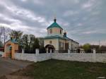
- name of the Orthodox parish to which belonged agro-town Ostromeczewo at the beginning of the XXth century
 what years the Metric books about the born, married and dead of this parish have survived;
- The fund number, the inventory, and the address of the Archive in which the metric books are stored;
- name of the Catholic parish to which belonged agro-town Ostromeczewo at the beginning of the XXth century
- what years the Metric books about the born, married and dead of this parish have survived;
- address of the Archive in which the metric books are stored;
This information is available for registered users with a Premium plan.
Add the message
Messages:
Słownik Geograficzny Królestwa Polskiego...
Ostromeczew, na karcie Chrzanowskiego Ostromieczewo, wś, pow. brzeski, o 3 w. na płd.-zach od Łyszczyc, przy drodze z Brześcia do Wysokiego Litewskiego; własność ks. Aleksandra Puzyny.reply
Słownik Geograficzny Królestwa Polskiego...
Ostromeczewo, Ostromeczew, wś i dwa fol. nad rzka Luta, pow. brzeski gub. grodź., gmina Łyszczyce, 21 w. od Brześcia. Wś Ostromeczewo 29 dm., 348 rak., cerkiew, szkoła, ze wsią Ogrodniki Planta 463 dz.; jeden fol. Osuchowskich, ma 289 dz., drugi Puzynów 264 dz. Grupa kurhanów.reply
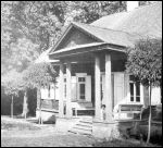
agro-town Ostromeczewo at photos from Radzima.org
photos added by Кузіч Мікола
photos added by К. Шастоўскі